
")
Flying over the islands
Ouessant Island and the Molène archipelago are located at the tip of Brittany between the Celtic Sea and Manche. These islands are subject to particularly harsh weather conditions. The combined action of the swell, generated offshore by the winds, and the tidal currents, some of the strongest in Europe, creates sea conditions once feared by all sailors.
Ouessant Island and the Molène archipelago are located at the tip of Brittany between the Celtic Sea and Manche. These islands are subject to particularly harsh weather conditions. The combined action of the swell, generated offshore by the winds, and the tidal currents, some of the strongest in Europe, creates sea conditions once feared by all sailors.
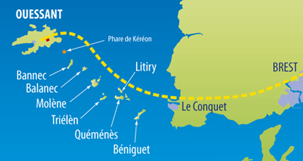
BENIGUET
A strip of land oriented south-west/north-east, the island extends over 2.5 km, with a maximum width of 300 metres. The coasts are sandy or covered in pebbles to the east, while the south and west are more rocky. The island contains traces of Neolithic occupation (menhirs and dolmens) and Roman occupation.
QUEMENES
It lies 2 nautical miles off the island of Molène and is 1.6 km long and 400 m wide. A smaller island, Lédénes de Quéménès, is often associated with it, the two islands being linked by a strip of pebbles that emerges at low tide.
Like the neighbouring islands, Quéménès was probably occupied as early as the Neolithic period, as evidenced by menhirs and megalithic chambers. Archaeological digs have also unearthed coins dating back to the Middle Ages.
LITIRY
The island, located 2 nautical miles from Béniguet and almost equidistant from Molène, is 700 metres long and 60 metres wide. It is separated from Quéménès, the nearest island, by a narrow channel. Another small channel separates Litiry from the island of Morgol, which is often associated with it.
TRIELEN
Triélèn is a small island in the Molène archipelago, 1 km long.
MOLENE
A small island measuring 1km by 900m, Molène (Molenez, Breton for bald island) is the main island in an archipelago of around twenty islands known as the Molène Archipelago. The island boasts a remarkable environment and incredibly clear seabed. From the air, at low tide, you can see a tiny island attached to it, called Lédénès de Molène.
BANNEC et BALANEC
Balanec is located 8.6 nautical miles from Le Conquet and 1.2 nautical miles from Molène. The island is 1 km long, with a maximum width of 750 m. It has four points, one of which is the Ror Han rock, which offers shelter above a small cove where you can disembark. There is an inner lake with brackish water. It is covered by sparse vegetation, mainly ferns and succulent grasses.
Baneg or Banneck in Breton: island of eminences (heights) located 2 km from Balanec and 4 km from Ouessant from which it is separated by the Fromveur. It is 0 km 800 long by 0 km 200 wide and covers an area of 11 hectares.
OUESSANT
Ouessant (Enez Eusa in Breton means ‘the highest’), an inhabited island measuring 7km by 4km, is also known as ‘the island of 5 lighthouses’, ‘the island of women’ or ‘the island at the end of the world’. Its shape is reminiscent of a crab claw, and it offers a unique and endearing heritage. This protected site is home to the Ornithological Observation Centre.
On-demand flight
CONTACT US
Phone: +33 2 98 84 64 87
Quote by email: info@finistair.fr
Capacity: 9 passengersQuote by email: info@finistair.fr